
So far, we’ve looked at artificial intelligence in the context of each specific industry that tries to keep up with the latest technological trends. But what if we look at AI more broadly to see how it can be applied to benefit the entire planet? Or maybe help collect data in areas that humans can’t get to? That is, more scalable and even more impressive AI. That’s right, today we’re going to talk about remote sensing, particularly about one of its many methods, LiDAR.
Remote sensing gives us the ability to observe the Earth and reach previously unexplored areas. It’s quite an extensive and diverse discipline that is applied to many industries today. To give you an idea, remote sensing is the process by which researchers can detect and monitor the physical attributes of an area and help them sense what’s happening on our planet. The researchers achieve this by using special cameras that measure reflected and emitted radiation from a distance on remotely sensed images. One of the most popular methods in remote sensing is LiDAR.
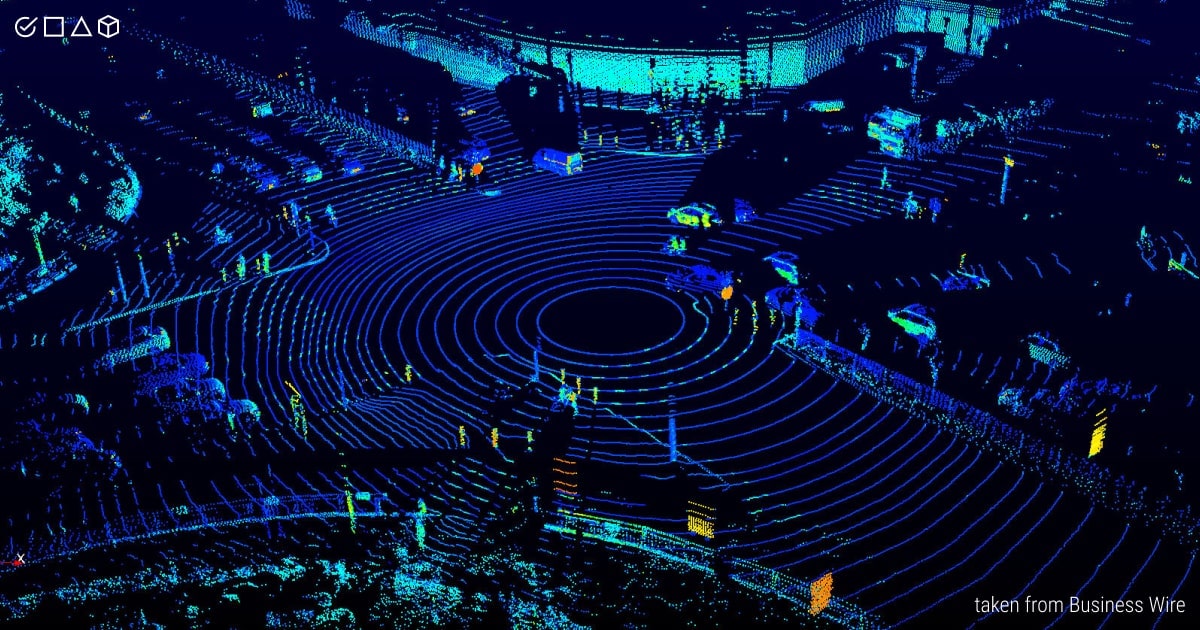
LiDAR, short for Light Detection and Ranging, is a remote sensing technology used to investigate the surface of the Earth. It operates using pulsed laser energy to gather data about the surrounding environment and objects in it, and measure ranges. This data is further used to create 3D models and maps of the objects and the environments.
According to research, from 2020 to 2027, the global LiDAR market is expected to grow at a CAGR of 20.1 %, reaching $2.90 billion. Such dynamics is explained by the fact that LiDAR systems produce highly accurate data and 3D images in less time, enabling an easier examination and mapping of different objects as compared to more conventional solutions. LiDAR sensors are even integrated into your iPhone, enhancing its camera and allowing for more rapid focus in low-light conditions. Moreover, LiDAR is the key ingredient for constructing self-driving vehicles, yet not without controversies. Not all the automotive industry’s leaders support the adoption of LiDAR in their work, like for example Elon Musk. Why is that so?
Let’s learn the ropes of using LiDAR technology to see why it has such a love-hate relationship with its users, and find out which group our team at Label Your Data belongs to! Do we love LiDAR or hate it? Take your guess and keep reading!
However, if you want to spare yourself a long read and get straight to the point, you can contact our team now , so we can annotate your 3D LiDAR data!
How Does LiDAR Technology Work?
Since remote sensing implies measuring things with sensors, not physically, LiDAR sends out intense, focused laser rays and measures (in a million points per second) how long it takes for the light energy to reflect using these sensors. Yet, this process is not as simple as it sounds.
LiDAR has proven itself as a reliable tool for gathering highly dense and precise elevation data of the landscapes, shallow-water areas, and project sites. This data is usually collected from planes to quickly gather points across broad regions, as well as mobile and ground-based stationary platforms. These data collection methods are essential for surveying and engineering communities since they can provide extremely high accuracies and point densities. As a result, LiDAR enables the creation of accurate, realistic three-dimensional models of railways, bridges, buildings, roadways, breakwaters, and other coastal infrastructure (and more).
So, how do LiDAR systems function? Light detection and ranging is an active remote sensing technique similar to radar, except instead of radio waves, LiDAR employs discrete laser light pulses to detect ranges to objects. The 3D coordinates of the target objects are received based on:
- The gap time between emission and return of the laser pulse
- The angle of the laser pulse
- The sensor’s exact position on or above the surface of the Earth
Components and Process Overview
Today, the most advanced LiDAR systems can send 500,000 pulses per second that are combined into a point cloud, aka a dataset of coordinates of the specific object. This dataset is then used to create a three-dimensional model of the examined object by LiDAR. How does this work? In general, a LiDAR system is made up of four main components, such as laser, scanner, sensor, and GPS (Global Positioning System):
- Laser. Sends laser pulses (ultraviolet, visible, or near-infrared) to the desired object (e.g., buildings, pedestrians, or cars). The type of light wave used depends, respectively, on the type of LiDAR.
- Scanner. Controls the laser’s scanning speed and range.
- Sensor. Measures the reflection time of the laser light from the target object and its return to the system.
- GPS. Tracks LiDAR’s location to ensure the most accurate distance measurements between the object and the system.
Altogether, these essential components of a LiDAR system ensure that the remote sensing process runs as smoothly as possible, providing the most accurate 3D data. Each LiDAR technology undergoes the same process:
- A LiDAR’s laser sends out a signal.
- A signal reaches the target object.
- A signal bounces off the object.
- It returns to a LiDAR’s sensor.
- A system computes the laser pulses.
- Each pulse is ascribed a location and representation in a LiDAR dataset (aka point cloud).
More specifically, a point cloud serves as a bridge between raw data gathered by LiDAR and 3D representations of the objects. It stores a vast amount of spatial data that can be further applied for various ML algorithms, analysis software, or any other AI project. For instance, LiDAR data can be used to produce highly precise maps of real-world environments or to accurately map the surroundings for a self-driving vehicle.
Here’s what this LiDAR math looks like in practice:

Types of LiDAR
In the course of learning about LiDAR, the following terms are often encountered, such as airborne or terrestrial LiDAR, or aerial or terrestrial laser scanning (ALS or TLS). A LiDAR device can be installed on an aircraft, helicopter, drone, ATV, vehicle, or tripod. The system uses a laser to scan the ground from above, which is why it's called airborne laser scanning. In addition, there’s a LiDAR dataset that is gathered from a satellite device, GLAS (Geoscience Laser Altimetry System). Let’s try to make sense of these terms now.
There are two main types of LiDAR:
-
Airborne (aerial) LiDAR scanning (ALS)
This type of LiDAR technology is mounted on a flying device, such as a drone or a plane. The system emits laser pulses to the ground to detect and examine the corresponding conditions. Airborne LiDAR is divided into two subcategories:
- Topographic (used to map the surface of the examined territory)
- Bathymetric (used to penetrate and estimate the depth of water bodies)
-
Terrestrial LiDAR scanning (TLS)
This type of LiDAR is installed on a moving vehicle or a tripod. It scans in all directions and converts point clouds into 3D models. There are two subcategories of terrestrial LiDAR:
- Mobile (used to observe roads, signs, pedestrians, and other infrastructure)
- Static (used to scan the surrounding environment or a particular feature)
-
There’s also an unmanned LiDAR scanning (ULS) that is applied to drones or other unmanned vehicles.
Modes of LiDAR
Also, LiDAR systems can be categorized based on their scanning modes and laser light energy. There are three main types of LiDAR in this context, such as:
-
Pulse-based (linear-mode) LiDAR
This system follows a typical process of LiDAR scanning. It’s called a linear-mode LiDAR because they only have one aperture to measure distance along a single vector at any moment. Pulse-based scanning is very common and is often what comes to mind when thinking of LiDAR.
-
Phase-based LiDAR
This mode of LiDAR systems uses interferometry to measure distances, which is the phase of a modulated laser light. The precision of phase-based systems can be on the scale of a few millimeters, although they are often employed for short-range scanning since they demand more energy compared to the other two modes.
-
Geiger-mode (photon-counting) LiDAR
This LiDAR mode is based on highly sensitive detectors, which can be activated by a single photon. Such a system may work at significantly greater altitudes than a linear mode system since just a single photon is required to activate a measurement. But since Ge-ger-mode LiDAR is relatively new, there’s a lot of noise and other operating constraints, making them far less prevalent than linear-mode LiDAR systems.
Benefits of LiDAR
LiDAR allows for comprehensive 3D information of the scanned objects and their surroundings. This opens up a lot of possibilities, especially where spatial data (think depth, distance, geometry, and size) is pivotal. For example, for inventory management in retail, or quality assurance (QA) in construction.
LiDAR bears a lot of benefits for the industries, not to mention the fact that this technology has been gaining popularity in the automotive industry (automotive LiDAR). Self-driving car manufacturers are commonly using LiDAR in their autonomous vehicle sensors to detect objects on the road/street, pedestrians, etc. to enhance ADAS (Advanced Driver-Assistance System) applications. Plus, as mentioned earlier in this article, LiDAR is integrated into smartphones, like iPhone 12 Pro, to enhance focused photos in portrait mode and distinguish foreground from distant background.
It’s just a drop in the ocean of what LiDAR systems can bring to the business world. What are the main benefits of LiDAR applications across modern industries?
- Accuracy
- Horizontal and temporal resolution
- 3D mapping
- Speed
- Low-light operation
If you're working on a LiDAR project right now, be sure to enlist the support of professional annotators to handle your 3D LiDAR data. Get in touch with our Label Your Data team and find the best solution for your project!
Key Applications of LiDAR Data

What exactly does LiDAR data represent? LiDAR point data includes laser time range, scan angle, GPS location, and INS information, which is post-processed and collected into highly precise georeferenced X, Y, Z coordinates by analyzing the above-mentioned points.
Many industries, including engineering and public safety, are using LiDAR data for a variety of tasks. Case in point, engineers and Earth scientists require LiDAR for the most accurate mapping and measuring of the surface of our planet, including buildings, shallow water, or underground.
LiDAR is an essential mapping and navigation technology that is used to equip robots. In the automotive industry, LiDAR data is applied for roadway safety, car accident prevention, and to basically save our lives. It’s also a commonplace technology that has been used for years in everyday life, including grocery stores (barcode scanning), light shows (event lightning), as well as home security. Besides, the LiDAR system is a useful tool used in agriculture (farming sensors) for crop protection and more efficient agricultural productivity.
This isn’t an exhaustive list of LiDAR capabilities. Among other industries, LiDAR data has a positive impact on:
- Astronomy
- Archeology
- Climate change
- Land mapping and management
- Oil and gas exploration
- Renewable energy
- Biology and conservation
- Forestry management
- Geology and soil science
- Surveying
LiDAR Annotation: Label Your Data Case Study
Our Label Your Data team of skilled annotators performed 3D LiDAR data labeling for smart traffic solutions. Let us tell you how this process went!
LiDAR point cloud data is a specific type of data that can only be handled by the pros. It requires skills and knowledge in order to correctly interpret and annotate this type of data. Our first LiDAR client's request was to label 12 different classes of objects with 3D cuboids on the LiDAR maps. However, our team has encountered some challenges in this project, such as the lack of instructions from the client, the absence of the client’s software for labeling, and the varying flow and amount of data. Nevertheless, the Label Your Data team has tackled the challenge and completed a 1000 frames pilot, with an experienced data annotator and the Account Manager creating a 22-pages guideline. These instructions contained a detailed description of each object, corner cases, software usage rules, and the FAQ section.
Contact us if you are working on any LiDAR project yourself and need professional help from data annotators! We provide a free pilot that is specifically customized to your project’s goals.
Summary: What Is the Future of Remote Sensing with LiDAR?
We’ve provided a brief overview of the main types and applications of LiDAR systems, with a pinch of our own experience of working with such data. Even though Elon Musk famously hates this technology and trusts solely computer vision, we believe that LiDAR systems and the 3D data they produce are powerful assets for the future of remote sensing.
This is due to LiDAR’s numerous solutions for a wide spectrum of enterprises and industries — large, medium, and small. LiDAR is relevant for an increasing variety of use-cases, whether your company focuses on agriculture, construction, astronomy, autonomous cars, conservation, or the Internet of Things (IoT).
With that said, LiDAR proves to be the primary candidate that can potentially transform the landscape of many industries in the future, including the automotive sector and AVs. So who knows, maybe Elon will change his mind one day? Label Your Data anticipates a promising future for LiDAR.
Table of Contents
![]() Get Notified ⤵
Get Notified ⤵
Receive weekly email each time we publish something new: