- Services
- Industries
- Team
- Company
- Articles
- Case Studies
- RUN FREE PILOT
Data Annotation for Drones and Aerial Imagery
Optimize your aerial imagery and drone-derived data for precise model training with our specialized drone data annotation services.
contact us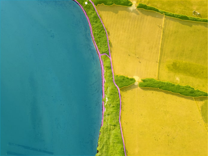
We Scale Teams for:


Drone Data Annotation Services at Label Your Data
Given that the global drone market is steadily growing, annotation services for drone data became a pivotal part of our comprehensive data labeling and processing solutions at Label Your Data. Autonomous flying objects, like drones, have permeated various industries. Thus, they require precision and expertise in distinguishing objects within aerial imagery. Our skilled annotators are adept at accurately labeling drone-captured data, ensuring its suitability for a wide range of applications.
Whether you need us to annotate drone data for construction site monitoring, precision agriculture or surveillance projects, our experienced team is ready to take on the challenge of the nuanced aerial data annotation. So if you need to train your ML model on the information from aerial imagery to perform tasks like object detection, terrain analysis, and environmental monitoring, rely on our dedicated team that will expertly Label Your Data.
Our Annotation Services for Drone Data & Aerial Imagery
In the area of annotation services for drone data, we work with all major drone annotation types and data formats. Our global team can expertly deliver the following drone data annotation services (but we are always open to your custom projects):
Bounding Boxes for Satellite Imagery
Semantic Segmentation for Roads
Polygonal Annotation for Solar Energy and Agriculture Tasks
Bounding Boxes for Military Technology
Polylines and Keypoints for Other Applications

We use bounding boxes to pinpoint rooftops and various objects within satellite images. These annotations are used for object detection and localization tasks.

Our expertise extends to semantic segmentation, enabling the accurate identification and classification of different road components, vital for drone navigation applications.
Our annotators offer drone data labeling for environmental projects using polygons. This annotation type allows defining the exact boundaries of elements, like solar panels, fields, forests, etc.
Through precise bounding box annotation, we enable object detection and localization tasks based on drone imagery. They help identify and track military assets and threats.

While less common, we also offer annotation services for polylines and keypoints when your project demands more specialized data representations.
Bounding Boxes for Satellite Imagery

We use bounding boxes to pinpoint rooftops and various objects within satellite images. These annotations are used for object detection and localization tasks.
Semantic Segmentation for Roads

Our expertise extends to semantic segmentation, enabling the accurate identification and classification of different road components, vital for drone navigation applications.
Polygonal Annotation for Solar Energy and Agriculture Tasks

Our annotators offer drone data labeling for environmental projects using polygons. This annotation type allows defining the exact boundaries of elements, like solar panels, fields, forests, etc.
Bounding Boxes for Military Technology
Through precise bounding box annotation, we enable object detection and localization tasks based on drone imagery. They help identify and track military assets and threats.
Polylines and Keypoints for Other Applications

While less common, we also offer annotation services for polylines and keypoints when your project demands more specialized data representations.
Domain Expertise
Proficiency in handling this specific data type is crucial. Our team is well-versed in labeling aerial imagery and drone photos in various annotation formats (JPEG, 3D images, and LiDAR drone images), often working with high-resolution images.
Personalized Strategy
We ensure a customized approach for each case since they all differ. This involves assembling an experienced team and aligning our efforts with your specific requirements, including data output, tooling, annotation submissions, and collaborative discussions on edge cases.
Scalable Solutions
When working with images from drones, our exceptional scalability allows us to swiftly expand the team’s capacity to annotate large volumes of drone data, ensuring rapid and efficient processing for your project.
Why Choose Aerial Data Annotation at Label Your Data?
Our company holds certifications for PCI DSS (level 1) and ISO:27001, and we adhere to the regulations outlined by GDPR, CCPA, and HIPAA. With 10+ years of experience and 500+ specialists on board, we provide customized annotation of datasets for drones and aerial imagery for enterprise and R&D projects in 55 languages.
Our Success Stories
High-volume aerial data annotation for warehouse automation tasks
Specialized team training for precise annotation of datasets for drones
Drone Data Annotation for Warehouse Efficiency
A US-based autonomous flying drones manufacturer focused on warehouse automation tasked Label Your Data with a brief project. Our annotators analyzed over 20,000 video frames, leveraging advanced aerial data annotation techniques for the detection of shelves, products, packages, and workers in warehouse environments. Our team’s focused training. in annotating drone data allowed us to provide our Client with the datasets they need to train their computer vision algorithms for enhanced warehouse automation.
Labeling complex aerial image data to enhance drone navigation capabilities.
Using semantic segmentation and object detection for precise drone data annotation.
Data Annotation for Drone Delivery Precision
For a leading drone delivery solutions provider in the U.S., our team analyzed 15,000 aerial images to enhance their drone navigation system. We were tasked to identify delivery zones and ensure obstacle-free paths. To do this, our experts labeled delivery points and potential obstacles using semantic segmentation for delineating objects and object detection for pinpointing specific elements. The resulting annotated dataset was used to refine our Client’s algorithms for optimized drone delivery routes and heightened efficiency in the delivery process.
Annotation precision demands posed by industry nuances.
In-depth client discussions to ensure accurate drone data annotation.
Aerial Data Annotation for Military Technology
For an ongoing MilTech (military technology) initiative, our team meticulously annotates drone footage. Specifically, we are classifying diverse elements like forests, roads, fields, buildings, and vehicles with nuanced attributes. This annotated data is pivotal for training the drone to autonomously ascertain its location if the operator connection is severed. Given the industry nuances, this case requires the batch-delivery approach, which is why we are often involved in detailed client consultations to address specific edge cases for enhanced performance.
Our Recent Articles
Send your data to us and get a free pilot
project!
CONTACT NOW
FAQs
What are the main types of drone image annotations?
The most common types of data annotations used for aerial imagery and drone data include bounding boxes, polygons, keypoints, and semantic segmentation.
How is aerial data annotation impacting major industries?
Aerial data annotation is revolutionizing industries like agriculture, urban planning, and infrastructure development by enabling precise analysis of aerial imagery for applications like crop monitoring, city mapping, and construction site optimization.
How do you capture data from a drone?
In case you need to capture drones images for your project, you deploy drones equipped with cameras or sensors to collect aerial data.
How does the annotation of datasets for drones enhance the accuracy and efficiency of aerial data analysis?
Most services for annotating drone data provide expertly labeled datasets that enable ML algorithms to recognize and interpret aerial data more effectively, thereby enhancing its accuracy and efficacy.