-
Services
computer vision
self-serve
- Industries
- Pricing
- About
- Careers
-
Resources
- talk to us
Academia
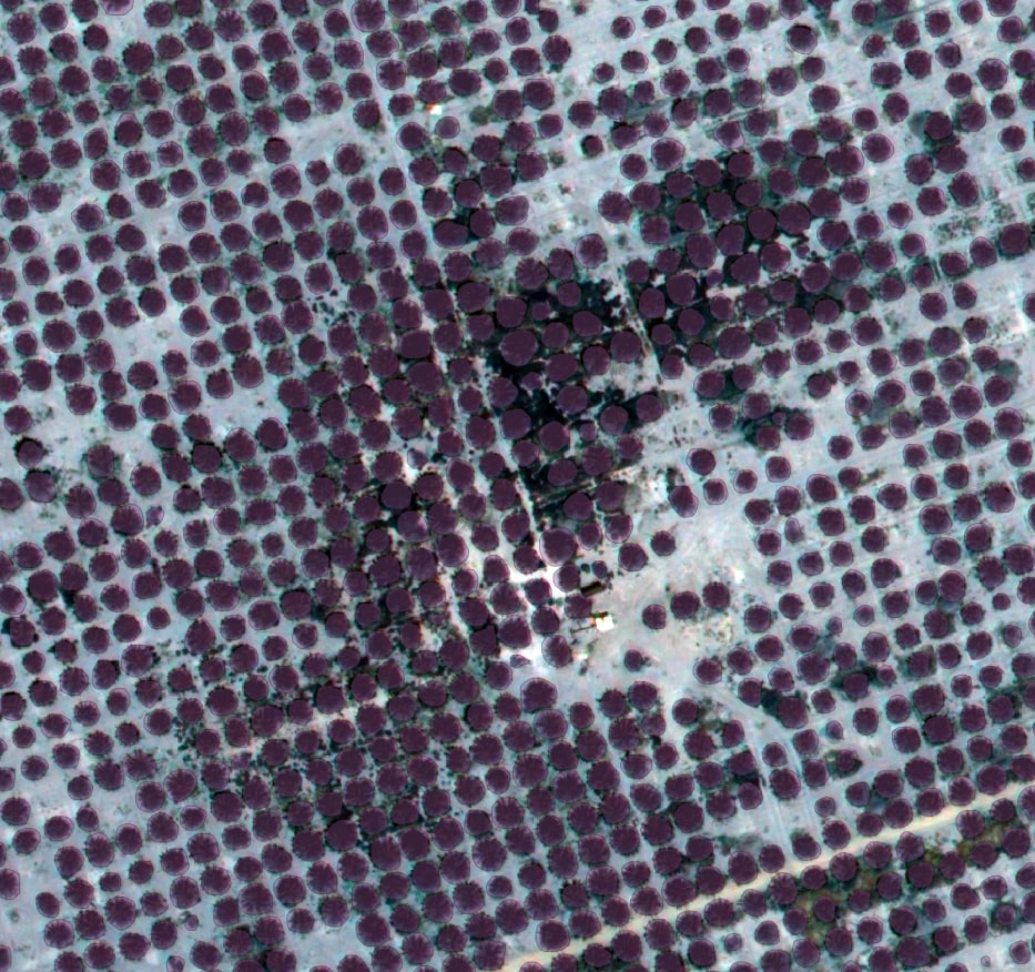
Polygon Annotation for Palm Tree Detection in Aerial Imagery
Overview
King Abdullah University of Science and Technology (KAUST) partnered with Label Your Data to advance palm tree detection models using aerial imagery.
Client
Saudi university applying AI to agricultural monitoring with aerial imagery.
Challenges
Overlapping canopies and irregular crowns made annotation slow and inconsistent.
Solutions
Polygon annotation with pilot validation and QA reviews for top-notch dataset quality.
Results
Dataset delivered with 98%+ accuracy, boosting model training efficiency.
Client
King Abdullah University of Science and Technology (KAUST) is a leading Saudi research university. The client needed annotated aerial imagery to train AI models capable of detecting palm trees for agricultural monitoring and environmental research projects.


Challenges
Large and complex aerial imagery required specialized tools
Inconsistent labels from external annotators slowed down cleaning
Manual filtering reduced research efficiency
Overlapping canopies and irregular crowns complicated labelin
Solution
Annotated a high-resolution TIF image in QGIS
Applied polygon annotation to mark palm trees across the dataset
Pilot phase: client reviewed the first 10% before scaling
A dedicated annotator ensured consistency and quality
Training
A single annotator was trained in QGIS using client-provided guidelines.
The pilot phase refined instructions through feedback loops,
ensuring alignment and accuracy before scaling to the full dataset.
Results
The project was delivered in 17 days with measurable outcomes:
98%+ accuracy, verified by the client
Dataset enabled successful palm tree detection model training
Generalized well across regions, improving research reliability
Researchers saved time by avoiding manual filtering

Request a pilot
Tell us more about your project and data
Thank you for contacting us!
We'll get back to you shortly
The collaboration with Label Your Data was seamless, allowing us to focus on palm tree detection model development instead of spending valuable time on meticulous manual labeling
PhD student of Computer
Science
Trusted by ML Professionals
Why AI Teams Choose Label Your Data
Data Annotation for Complex Environments
Rely on consistent, high-quality output for complex datasets, detailed taxonomies, and edge cases.
Structured Quality from Pilot to Production
Get quality engineered into every step through onboarding, evolving guidelines, QA, and continuous feedback.
Flexible and Scalable Operations
Adjust team capacity, project size, and delivery model as you scale, with no setup fees or long-term lock-ins.
An Integrated Delivery Partner
Align on goals, workflows, and expectations with a team that integrates into your process from day one.
Projects Led by Annotation Experts
Work with former annotators who understand annotation complexity, quality standards, and high-volume delivery.