


 Back to blog
Data Annotation for Autonomous Vehicles: Best Practices in 2026

 CEO of Label Your Data


Table of Contents

- TL;DR
- Types of Autonomous Vehicle Training Data
- How Data Annotation for Autonomous Vehicles Improves Model Safety
- Key Techniques Used in Data Annotation for Autonomous Driving
- Challenges in Data Annotation for Autonomous Vehicles
- How We Help AV Teams Overcome These Challenges
- About Label Your Data
- FAQ
TL;DR
- Modern AV systems need precise and diverse labels to understand objects, road areas, movement, and edge cases in different driving scenarios.
- Autonomous vehicle data requires different annotation methods, from 2D boxes for camera footage to 3D cuboids for LiDAR and tracking IDs across the frames.
- In data labeling for autonomous vehicles, data quality, sensor synchronization, unclear cases, privacy, and small errors can all affect your model performance.
- The best annotation strategy for AVs implies hybrid workflows, human-led QA, and ongoing label updates as the model and driving scenarios change.
Deficiencies in training and validation data for autonomous vehicles (AVs) “can lead to catastrophic failures in real-world scenarios.” In other words, if your data is incomplete, inconsistent, or poorly annotated, the AV model inherently learns the wrong patterns.
To build reliable object detection models for safe self-driving, you need high-quality data annotation for autonomous vehicles since public datasets rarely fulfill the specific requirements of real-world driving scenarios, sensor setups, and edge cases.
In this article, we explain what data you need to train machine learning models for AVs, how to process and label that data, and where to get the best autonomous vehicle training data for your next project.
Types of Autonomous Vehicle Training Data
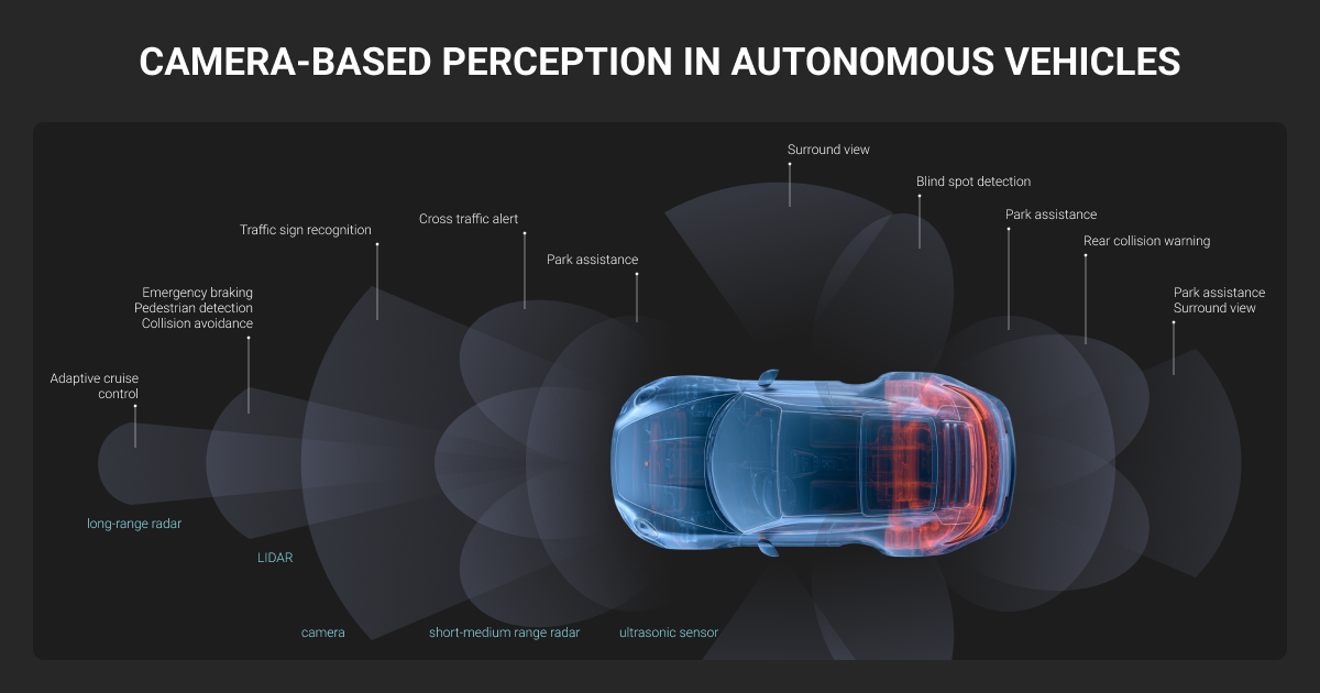
Camera image and video footage, LiDAR points, radar streams, and multisensor synchronized data are the main types of autonomous vehicle training data. Each modality captures a different slice of the driving environment, and models rely on their overlap to perceive reliably across weather, lighting, and traffic conditions.
Camera autonomous vehicle data
As one of the core inputs for AV systems, camera image and video data supports image recognition tasks, helping models identify:
- Lane markings
- Traffic lights
- Road signs
- Pedestrian gestures
- Vehicle types
- Road conditions
Video frames add temporal context to help models understand motion, intent, and scene changes over time.
LiDAR point cloud data
LiDAR uses laser pulses to measure distance and capture the vehicle’s surroundings as a dense 3D point cloud. These sensors generate millions of points per second. They allow autonomous systems to understand distance, shape, and position far better than a regular camera alone.
Still, raw 3D point clouds don’t explain what those objects actually are. A set of points itself means little. You need an expert LiDAR annotation team to turn them into a machine-readable format. Only then a model understands the difference between a cyclist, a curb, a parked car, or a road barrier.
Radar stream data
Radar uses radio waves to help autonomous vehicles understand what’s around them. It helps maintain perception performance in conditions that can reduce camera visibility, such as:
- Rain
- Fog
- Dust
- Glare
- Low light, etc.
Radar streams stay reliable in conditions that degrade cameras and LiDAR, such as fog, rain, snow, and glare, and they measure object velocity directly, so they give autonomous systems a dependable read on the road when other sensors struggle.
Multi-sensor synchronized data
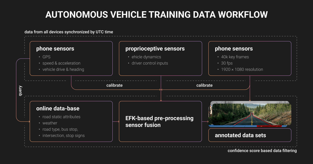
Production-grade AV systems rarely rely on a single sensor; they combine cameras, LiDAR, radar, GPS, and IMU inputs. To train self-driving machine learning algorithms the right way, all that sensor data must be time-synced and labeled consistently across modalities.
For example, the same pedestrian may need to align across image frames, LiDAR space, and radar returns. This makes multimodal machine learning datasets difficult to annotate, as even small mismatches in timing, object IDs, or sensor calibration can affect label consistency.
A well-known example of this is the nuScenes dataset for autonomous driving. It includes real-world urban scenes captured with cameras, LiDAR, radar, GPS, and IMU sensors.
Datasets like nuScenes are useful for research and benchmarking. However, since public datasets may not match a specific sensor setup, region, taxonomy, or edge cases, real-world AV projects still require custom annotation work.
How Data Annotation for Autonomous Vehicles Improves Model Safety
Autonomous vehicle systems don’t learn from raw sensor feeds. They learn from accurate ground truth data: the labeled, verified annotations that tell a model what each camera, LiDAR, and radar input actually represents.
High-quality autonomous vehicle data labeling improves:
- Perception accuracy. Annotated data helps AV models identify vehicles, pedestrians, cyclists, traffic signs, lane markings, road boundaries, and many other objects in complex scenes.
- Safer path planning. To decide where the vehicle can move, the system has to understand lanes, curbs, free space, obstacles, crossings, and areas that should be avoided.
- Motion understanding. It’s not enough to detect an object once. AV systems also need to track objects across frames, understand how they move, and predict what they might do next.
- Model evaluation. Labeled datasets are also used to measure how well a model performs. They help calculate precision, recall, false positives, missed detections, and other model performance metrics.
- Edge-case readiness. Real roads are unpredictable. Snow, night driving, damaged signs, unusual pedestrian behavior, and rare traffic scenarios all require carefully labeled examples so the model can learn how to handle them.
The better that ground truth is, the better your driverless model can understand the road scenes, make predictions, and respond safely in real-world driving conditions.
Key Techniques Used in Data Annotation for Autonomous Driving
Core data annotation techniques for autonomous driving models include:
- 2D bounding boxes
- Cuboids
- Sensor fusion
- Polygons
- Segmentation masks
- Temporal tracking
- And AI-assisted labeling with human QA
Each annotation technique supports a different part of the autonomous driving stack. In practice, though, AV projects rarely rely on one annotation type only.
2D bounding boxes for camera footage
2D bounding boxes are rectangular boxes placed around visible objects such as:
- Cars
- Pedestrians
- Cyclists
- Traffic signs
- Traffic lights
- Road barriers
- And other traffic participants
This data annotation autonomous driving technique gives object detection models for autonomous systems a clear target. The model learns what class the object belongs to and where it appears in the image.
Bounding box annotation is also relatively fast to create and review. As such, it’s practical for large autonomous driving datasets.
The limitation is that a 2D box only describes an object in a flat image. It doesn’t tell the model enough about real-world distance, three-dimensional space, or orientation. For many perception tasks, that’s fine as a starting point. But for autonomous driving projects, you need other types of annotation for reliable model output.
Cuboids for LiDAR point clouds
3D cuboids are used to label objects in LiDAR point clouds and other 3D annotation datasets.
Unlike a 2D bounding box, a cuboid shows where an object sits in physical three-dimensional space, helping the vehicle understand not only that another car or object exists, but also:
- How far away it is
- How much room it takes up
- Whether it is aligned with the lane
- How it may affect the vehicle’s path
That extra spatial context matters a lot in data annotation for autonomous driving, because a label off by even a few centimeters can teach the model to misjudge where a pedestrian or vehicle is.
Sensor fusion annotation
Sensor fusion annotation processes the same scene across several sensors, such as cameras, LiDAR, and radar. Each sensor adds different information:
- Cameras show the scene in images
- LiDAR adds depth and 3D shape
- Radar helps measure distance and speed
The goal of this data annotation autonomous driving approach is to keep the labels consistent.
A pedestrian in a camera image should match the same LiDAR points and radar signal. This helps the model connect visual appearance, 3D position, distance, and motion into one reliable object representation.
Polygon and segmentation masks
Polygon annotation means placing points along the edges of an object or road area and connecting them into a precise shape. Segmentation masks go further and do the image annotation for autonomous vehicles pixel by pixel.
These methods help mark road elements that don’t fit well inside a box, such as traffic islands or crosswalks, to name a few. It helps autonomous driving systems understand where the road begins, where it ends, and which areas are safe to enter.
Temporal tracking across frames
Temporal tracking follows the same object across video frames or LiDAR sequences. Data annotators don’t label a car, a cyclist, or a pedestrian only once; they track each object over time and give it the same tag in each frame.
A self-driving model needs to understand where an object goes, how fast it moves, and what it might do next. For example, there’s a cyclist standing near the road and a cyclist starting to move into traffic. They may look similar in one frame. But across several frames, their behavior is very different.
The goal of expert data annotation for autonomous vehicles is to translate this difference into a machine-readable format for the AV model training.
AI-assisted data annotation for autonomous vehicles
AI data labeling uses an ML model to generate initial annotations. Trained QA reviewers then correct, refine, and validate these automated labels.
Automatic labeling is especially useful for large datasets with millions of camera frames, video sequences, or dense LiDAR point clouds.
You can choose among a few open-source data annotation tools that can label data for your AV model.
| Tool | Type of tool | Best for | Why it matters |
| CVAT | General annotation platform | Image, video, and 3D annotation workflows | Good option when a team needs one flexible tool for different AV data types, including camera data and point clouds. |
| SUSTechPOINTS | 3D point cloud annotation tool | LiDAR 3D bounding boxes | Built for labeling objects in point clouds, such as cars, pedestrians, and cyclists. |
| labelCloud | Lightweight 3D point cloud labeling tool | Smaller LiDAR or 3D object detection projects | Useful when teams need a simple tool for creating 3D boxes in point cloud data. |
| ReBound | LiDAR visualization and annotation tool | Active learning workflows | Helps review and edit LiDAR annotations, including model-generated labels. |
| LATTE | Semi-automated LiDAR annotation tool | Faster point cloud labeling | Supports a more automated workflow for LiDAR labeling, including tracking and sensor-fusion-based assistance. |
| Awesome LiDAR Labeling | Curated GitHub list | Tool research and comparison | Useful when teams want to explore more open-source LiDAR annotation tools in one place. |
But even the most advanced automation of data labeling for autonomous vehicles still requires precise human control.
Autonomous vehicle data includes edge cases, such as poor lighting, occlusions, construction zones, bad weather, and unusual road behavior.
That is why the strongest setup is usually human-in-the-loop labeling.
Challenges in Data Annotation for Autonomous Vehicles
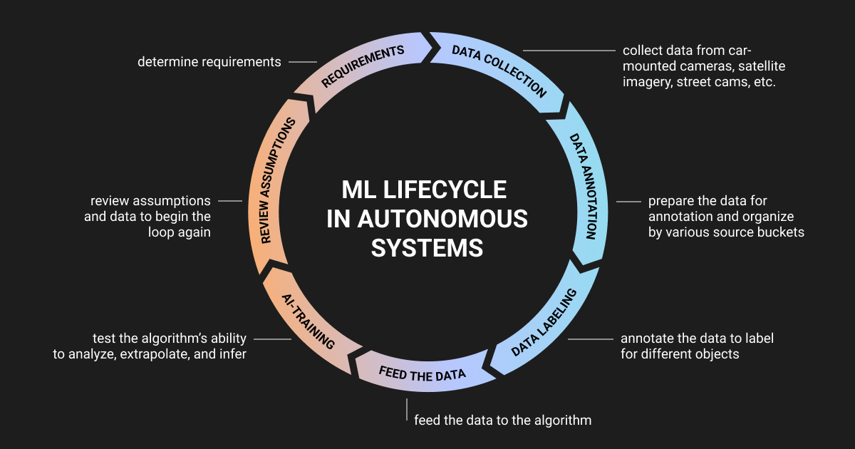
Autonomous vehicle data labeling has to stay accurate across a huge range of road scenes, sensor types, and edge cases. The key challenge is to be consistent when the data is messy, the scenario is rare, and the same object looks different across different data sources.
Data collection
The first challenge is getting enough autonomous vehicle data for training and validation.
Driverless models need large amounts of data from different sources to learn from both common situations and rare edge cases. That’s why autonomous vehicle data collection is an important part of any AV project.
Data complexity
Driving behavior, road layouts, signs, lane markings, weather, and visibility can vary a lot between cities and countries. A model trained on data from one deployment region may not perform well in another without localized data.
Autonomous vehicle data annotation often involves unclear cases. Is a partially blocked lane still drivable? Should an e-scooter rider be labeled as a pedestrian, cyclist, or separate road user? Should a damaged sign be labeled as a sign, an obstacle, or ignored?
You may also need to label:
- Blurry frames
- Low-visibility scenes
- Sensor sync issues
- Missing objects
- Inconsistent class names
- Rare scenarios with too little training data
This makes autonomous vehicle data labeling more complex than standard image annotation. That complexity is easier to handle with managed data annotation services and clear data annotation pricing, where clear labeling rules, trained annotators, and quality checks help keep the dataset consistent and accurate.
Autonomous vehicle data privacy
Autonomous vehicle datasets can capture sensitive details, including:
- Faces
- License plates
- Homes
- Other private property
- People’s behavior in public spaces
Before using this data for model training, you need to anonymize personal information, restrict access, and follow relevant data protection requirements. This is especially true when projects involve real-world road footage collected across different regions.
How We Help AV Teams Overcome These Challenges
As a specialized data annotation company, Label Your Data has mastered the data labeling process for AV projects over the last six years. Here, we share some real-world client stories where our team helped tackle the autonomous vehicle data challenges discussed above.
Polygon annotation for 3D depth models
A 3D computer vision company, Nodar, needed high-precision polygon annotations to train and validate depth-mapping models for autonomous driving.
Challenge: Public datasets couldn’t fully cover sensor-specific objects and edge cases.
How Label Your Data helped Nodar:
- Labeled roads, vehicles, terrain, airport equipment, and people
- Created layered polygon masks for depth modeling
- Started each batch with a pilot task, client feedback, guideline refinement, annotator training, and QA review
- Scaled the team to 10-20 annotators and 2-3 QA reviewers
Result: Around 60,000 expertly labeled polygon masks by Label Your Data helped reduce validation cycles and support multiple model pipelines for Nodar.
LiDAR annotation for enhanced detection and tracking
For Ouster, a leading provider of high-performance lidar sensors, the main challenge was working with diverse LiDAR datasets from static and dynamic sensors across different environments. Their autonomous vehicle data required accurate 2D bounding boxes and 3D cuboids that could support object detection and tracking inside their ML pipeline.
Challenge: Cuboid position, size, and orientation had to stay consistent for object detection and tracking.
How Label Your Data helped Ouster:
- Created a dedicated annotation guide
- Trained each new team member before scaling
- Grew the team from 2 to 10 annotators
- Built QA into the workflow to control cuboid accuracy and label consistency
Result: LiDAR annotation provided by the Label Your Data team enabled Ouster to perform accurate performance regression analysis, boosting their product performance up to 20% and improving multi-object tracking accuracy up to 15%.
Autonomous vehicle training data for Formula Student
Elefant Racing needed labeled autonomous driving datasets to train their ML algorithm for its first driverless Formula Student race car. The team had strong engineering expertise, but they lacked the resources and expertise needed to prepare training data at the required quality level.
Challenge: The team lacked enough annotation capacity and knowledge to prepare training data on time.
How Label Your Data helped Elefant Racing:
- Expert bounding box annotation to help the model recognize objects around the car
- Keypoint annotation to track traffic cones
- Supported the project over several months as the team prepared for Formula Student events
Result: Label Your Data annotated ~2,500 images with 25K boxes and 172K keypoints, helping the Elefant Racing team compete and succeed in Formula Student competition.
About Label Your Data
If you choose to delegate data annotation for autonomous vehicles, run a free data pilot with Label Your Data. Our outsourcing strategy has helped many companies scale their AV projects. Here’s why:
 Data Annotation for Complex Environments
Rely on consistent, high-quality output for complex datasets, detailed taxonomies, and edge cases.
 Structured Quality From Pilot to Production
Get quality engineered into every step through onboarding, evolving guidelines, QA, and continuous feedback.
 Flexible and Scalable Operations
Adjust team capacity, project size, and delivery model as you scale, with no setup fees or long-term lock-ins.
 An Integrated Delivery Partner
Align on goals, workflows, and expectations with a team that integrates into your process from day one.
 Projects Led by Annotation Experts
Work with former annotators who understand annotation complexity, quality standards, and high-volume delivery.
FAQ
What is data annotation for self-driving cars?
Data annotation for self-driving cars means labeling road data so perception models learn what each sensor input represents. Annotators draw 2D and 3D bounding boxes around vehicles and pedestrians, segment lanes and drivable surface at the pixel level, mark traffic signs and lights, and trace road edges, then carry those labels consistently across camera, LiDAR, and radar frames.
Which AI application is used in autonomous vehicles?
Autonomous vehicles use AI for object detection, lane and drivable-space segmentation, sensor fusion across camera, LiDAR, and radar, motion prediction, localization, and path planning.
How to analyze autonomous vehicle sensor data?
- Sync timestamps across cameras, LiDAR, radar, GPS, and IMU.
- Calibrate the sensors to use the same coordinate frame.
- Annotate and track objects across frames.
- Fuse data from all sensors into one scene.
- Compare model predictions with ground truth labels.
- Measure performance using metrics such as mAP for detection and IoU for segmentation.
Written by
CEO of Label Your Data
Karyna is the CEO of Label Your Data, a company specializing in data labeling solutions for machine learning projects. With a strong background in machine learning, she frequently collaborates with editors to share her expertise through articles, whitepapers, and presentations.