LiDAR Annotation: What It Is and How to Do It
Table of Contents

TL;DR
- LiDAR annotation labels 3D point cloud data to train AI models for tasks like object detection and classification.
- Applications include autonomous vehicles, urban planning, and environmental monitoring.
- Annotation types include 3D bounding boxes, semantic segmentation, and polylines.
- Challenges involve processing large datasets, handling overlaps, and ensuring consistent annotations.
- Future trends emphasize automation, sensor fusion, and broader use in industries like healthcare and logistics.
What is LiDAR Annotation?
LiDAR annotation involves labeling 3D data collected by LiDAR (Light Detection and Ranging) sensors. They emit laser pulses to measure distances, creating a 3D point cloud of the environment.
Annotating this data teaches machine learning models to identify and classify objects like vehicles, trees, and buildings in three-dimensional space.
LiDAR is essential for applications that need precise spatial data (e.g., satellite vs. drone imagery). Autonomous vehicles, urban planning, and environmental monitoring all rely on annotated LiDAR data for accurate insights and real-time decision-making.

How LiDAR Annotation Works
The data annotation process consists of a few key steps:
Data Collection
LiDAR sensors generate millions of 3D data points by emitting lasers and measuring their reflections.
Labeling
Raw LiDAR data often starts as unlabeled data, requiring detailed annotation to make it usable for training ML models. Annotators use specialized data annotation tools to define objects within the point cloud.
Common techniques include:
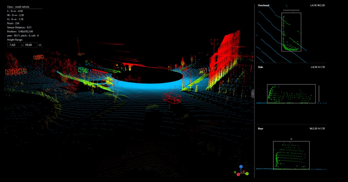
- 3D bounding boxes to mark object dimensions.
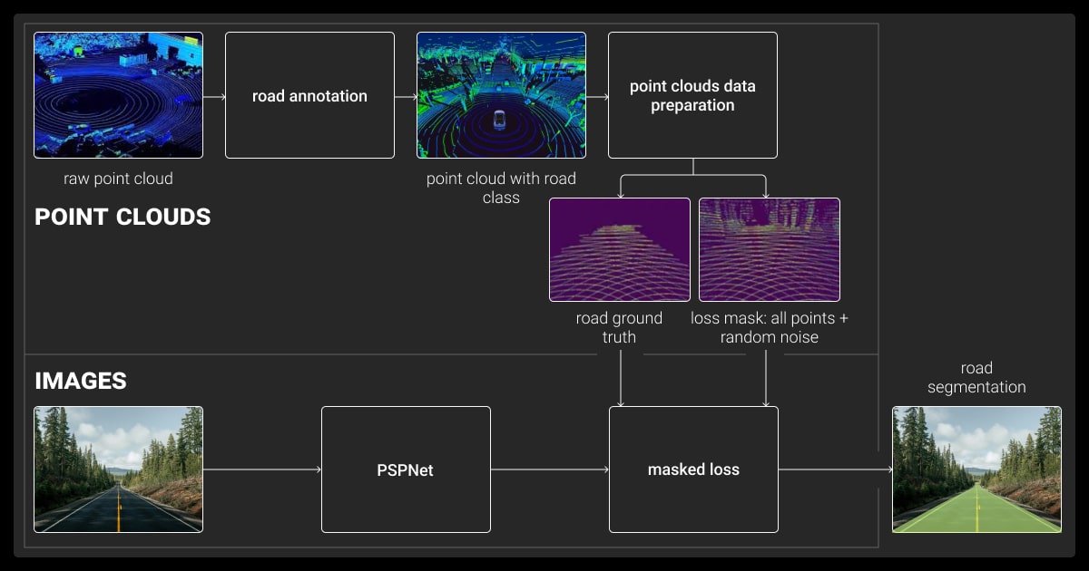
- Semantic segmentation to label each point by category.
- Polylines and polygons to outline roads, paths, or areas.
Using Annotation Tools
Advanced tools simplify labeling with features like brush selection for bulk annotations and AI-assisted automation.
Applications Across Industries
| Industry | Example Use Case |
| Autonomous Vehicles | Detecting pedestrians, vehicles, and road features. |
| Urban Planning | Creating detailed 3D maps for city design. |
| Environmental Monitoring | Assessing terrain, vegetation, and natural resources. |
Besides, LiDAR data complements image recognition by adding depth and spatial details for more robust AI models.
LiDAR Annotation Benefits

3D LiDAR annotation is a critical step in transforming raw 3D point cloud data into actionable insights. Without proper labeling, machine learning models cannot identify or interpret objects effectively in a 3D environment.
Here’s why it matters:
Training Reliable Machine Learning Models
Annotated LiDAR data serves as the foundation for training models in tasks like object detection, classification, and segmentation. Accurate labels improve model performance and reduce errors in real-world applications.
Supporting Automation
Applications like autonomous vehicles and robotics depend on annotated data to make decisions. For example:
- Autonomous Vehicles: Use annotated LiDAR data to recognize pedestrians, vehicles, and road signs.
- Robotics: Navigate dynamic environments by detecting obstacles.
Enabling Better Insights
LiDAR annotation supports industries that rely on 3D mapping and monitoring:
- Urban Planning: Annotated data is used to create detailed maps for infrastructure projects.
- Environmental Research: Tracks changes in terrain and vegetation, aiding conservation efforts.
Accurate LiDAR annotation improves the performance of any machine learning algorithm used for tasks like autonomous navigation.
Example Scenarios
| Industry | Specific Impact |
| Self-Driving Cars | Detect obstacles and avoid collisions in real-time. |
| Construction | Plan infrastructure projects with accurate 3D data. |
| Forestry | Monitor forest health and track deforestation patterns. |
LiDAR annotation bridges the gap between raw data and actionable outcomes, enabling AI systems to perform reliably in diverse and complex scenarios.
Types of LiDAR Annotation
3D LiDAR annotation uses several methods to label 3D data effectively. Each technique caters to specific machine learning tasks and industry requirements.
Here’s a breakdown:
3D Bounding Boxes
- Define the dimensions of objects within the point cloud.
- Commonly used in applications like autonomous vehicles to detect cars, pedestrians, and other objects.
Semantic Segmentation
- Labels each point in the cloud with a category (e.g., "road," "tree," "building").
- Helps create detailed maps and identify areas of interest.
Instance Segmentation
- Differentiates between individual objects within the same class.
- Useful in tasks like separating vehicles in dense traffic or trees in a forest.
Polylines and Polygons
- Mark roads, paths, and other linear or area-specific features.
- Commonly used in urban planning and construction.
How to Choose the Right Annotation Type for LiDAR
| Annotation Type | Best For | Examples |
| 3D Bounding Boxes | Object detection and tracking | Cars, pedestrians, and bikes in traffic scenes |
| Semantic Segmentation | Scene understanding | Roads, buildings, and vegetation |
| Instance Segmentation | Identifying individual objects within a class | Cars in a parking lot |
| Polylines/Polygons | Linear and area features | Roads, walkways, and building perimeters |
Selecting the right annotation type depends on the task's goal. Combining multiple techniques often results in more robust machine learning models.
How Is LiDAR Annotation Done?
LiDAR annotation involves several steps, tools, and techniques to transform raw point cloud data into labeled datasets. This process is critical for training machine learning models that rely on 3D data.
Step-by-Step Process
Collect Point Cloud Data
LiDAR sensors capture 3D spatial data by emitting laser pulses and measuring their reflections. The result is a dense collection of data points representing the environment.
Preprocessing
- Filter out noise and irrelevant data.
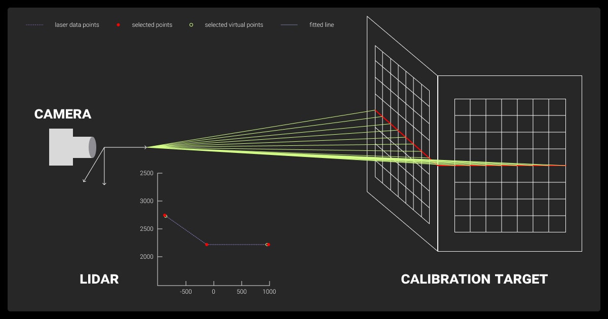
- Align multiple point cloud datasets if required, using sensor fusion techniques.
Annotation
- Label objects using techniques like 3D bounding boxes, semantic segmentation, or polylines.
- Annotators use specialized tools to navigate, label, and review the 3D space.
Quality Assurance
- Validate annotations to ensure accuracy and consistency.
- Use multi-level reviews or automated validation tools to catch errors.
Just as LLM data labeling ensures accurate training for language models, precise labeling is essential for training LiDAR-based AI systems.
LiDAR Annotation Tools
| Tool | Features | Best For |
| SuperAnnotate | AI-assisted labeling, brush tools | Complex projects requiring semantic segmentation |
| Dataloop | Collaboration and scalability options | Large-scale annotation tasks |
| Label Studio | Open-source, customizable workflows | Projects with diverse labeling needs |
Challenges in LiDAR Annotation
- Handling Large Datasets: LiDAR data is massive, requiring tools that can process and visualize millions of points efficiently.
- Occlusion Issues: Overlapping objects make it difficult to label points accurately.
- Consistency: Maintaining annotation quality across large datasets is labor-intensive.
How Data Annotation Services Help
Many companies outsource 3D LiDAR annotation to professionals who specialize in handling these challenges. Data annotation services provide:
- Expert annotators familiar with LiDAR data.
- Scalable workflows to manage large projects efficiently.
- Multi-level quality control to deliver consistent results.
Partnering with a reliable data annotation company ensures consistent results for complex LiDAR tasks.
Implement a multi-stage validation workflow using an ensemble approach where three independent annotators mark each point cloud segment, with an AI-powered anomaly detection system flagging significant discrepancies. This ensures nuanced, high-complexity regions receive specialized human attention.
LiDAR Annotation in Autonomous Vehicles

By 2030, the automotive software and electronics market will reach $462 billion, with LiDAR sensor adoption for ADAS growing by up to 30% annually. This growth underscores LiDAR’s key role in autonomous vehicle innovation.
LiDAR annotation, in turn, plays a central role in enabling autonomous vehicles to navigate safely and efficiently. By labeling 3D point clouds, machine learning models can detect, classify, and track objects in real time.
How Autonomous Vehicles Use LiDAR Data
Object Detection and Tracking
- LiDAR helps vehicles identify pedestrians, other vehicles, and obstacles.
- Annotated 3D data allows models to track moving objects accurately, ensuring safety in dynamic environments.
Mapping and Localization
- LiDAR provides detailed 3D maps for navigation, identifying road structures, traffic signs, and lane markings.
- High-quality annotations improve the vehicle's ability to localize its position within these maps.
Environmental Understanding
- Semantic segmentation of LiDAR data helps vehicles recognize road types, parking lots, and construction zones.
- This understanding aids decision-making, such as determining safe paths or avoiding hazards.
Benefits of Accurate LiDAR Annotation for Self-Driving Cars
| Benefit | Description |
| Improved Safety | Recognizes and avoids obstacles with high precision. |
| Enhanced Decision-Making | Detects objects and evaluates paths for safe navigation. |
| Better Adaptability | Handles complex scenarios like urban traffic or intersections. |
One quick tip for high-quality LiDAR annotation is to use multiple review layers. After the initial annotations, it's important to go back and review the data multiple times from different perspectives. This helps catch inconsistencies or errors that might have been missed in the first pass.
Best Practices for LiDAR Annotation

Accurate 3D LiDAR annotation requires a strategic approach to ensure consistency and quality. Following best practices can improve the efficiency of the annotation process and the reliability of the resulting datasets.
Focus on Data Quality
- Use clean, noise-free point cloud data to avoid labeling irrelevant or redundant points.
- Preprocess data by removing artifacts and aligning multiple datasets for consistency.
Use Advanced Annotation Tools
- Choose LiDAR annotation tools with features like 3D visualization, brush selection, and AI-assisted labeling.
- Opt for scalable platforms that can handle large datasets and support collaborative workflows.
Maintain Consistency Across Teams
- Develop clear annotation guidelines, including labeling standards and class definitions.
- Conduct training sessions for annotators to ensure everyone follows the same approach.
Implement Quality Control Processes
- Review annotations at multiple levels to identify and correct errors.
- Use automated validation tools to check for inconsistencies or missing labels.
Leverage Data Annotation Services
- Outsource large or complex projects to professional data annotation services.
- Benefit from expertise in LiDAR annotation, multi-stage reviews, and scalable workflows.
Establish clear annotation guidelines and perform regular quality checks. Clear guidelines should define parameters like object labeling accuracy, class definitions, and segmentation rules to ensure consistency across annotators. Regular feedback loops between annotators and QA teams also help refine processes and maintain high standards.
Why These Practices Matter
Adhering to these practices minimizes errors, reduces annotation time, and ensures high-quality datasets for training machine learning models. Accurate LiDAR annotation directly impacts the performance of AI systems in applications like autonomous driving, urban planning, and robotics.
Future Trends in LiDAR Annotation
LiDAR annotation is evolving rapidly as new technologies and techniques emerge to handle the increasing demand for 3D data in AI applications. These trends are shaping how annotation processes will look in the near future.
Automation and AI-Assisted Annotation
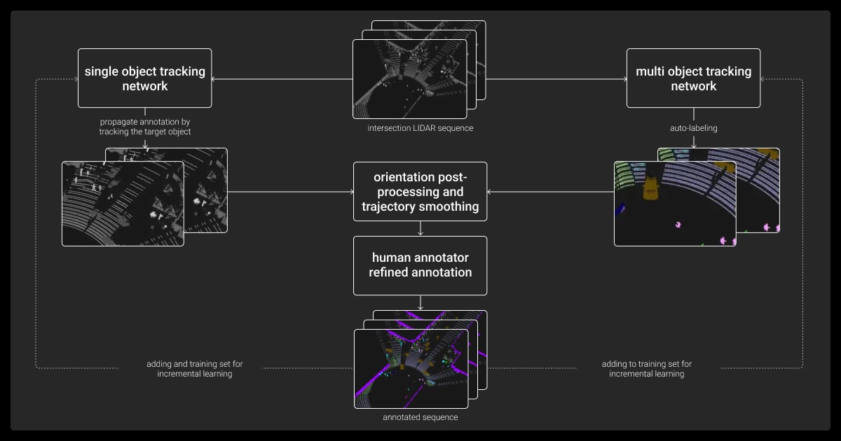
AI-driven tools are streamlining annotation by automating repetitive tasks, reducing manual effort, and enhancing speed and consistency.
Integration with Sensor Fusion
LiDAR is increasingly combined with camera and radar data, boosting annotation accuracy and enabling critical applications like autonomous navigation.
Expanding Use Cases
LiDAR annotation is expanding beyond autonomous vehicles to sectors like healthcare, logistics, geospatial annotation, and retail, driving demand for industry-specific solutions.
Advancements in Annotation Tools
New features like 3D brush tools, automated segmentation, and cloud-based platforms are making annotation more intuitive and efficient for teams.
Emphasis on Scalability
Annotation platforms are evolving to handle larger datasets, meeting the growing demands of industries like autonomous vehicles and environmental monitoring.LiDAR annotation is becoming faster, smarter, and more adaptable, enabling new possibilities for industries that rely on 3D data. Managing large-scale LiDAR projects often brings challenges, and data annotation pricing is a key factor to consider.
About Label Your Data
If you choose to delegate data annotation, run a free pilot with Label Your Data. Our outsourcing strategy has helped many companies scale their ML projects. Here’s why:
Check our performance based on a free trial
Pay per labeled object or per annotation hour
Working with every annotation tool, even your custom tools
Work with a data-certified vendor: PCI DSS Level 1, ISO:2700, GDPR, CCPA
FAQ
What is LiDAR in annotation?
LiDAR in annotation refers to labeling 3D point cloud data collected by LiDAR sensors. This process helps train AI models to identify and classify objects, such as vehicles, trees, or buildings, in three-dimensional space.
Is LiDAR annotation hard?
LiDAR annotation can be challenging due to the 3D nature of the data. Tasks like labeling millions of points, managing overlapping objects, and maintaining consistency require skill and attention to detail. However, modern tools with AI-assisted features make the process more manageable.
What is the LiDAR?
LiDAR (Light Detection and Ranging) is a technology that uses laser pulses to measure distances. It creates 3D representations of environments, capturing precise spatial information about objects, making it essential for applications like autonomous vehicles and mapping.
What tools are best for LiDAR annotation?
Popular tools include SuperAnnotate, Dataloop, and Label Studio. These platforms offer features like 3D visualization, AI-assisted labeling, and collaboration options to simplify the annotation process.
What industries rely on LiDAR annotation?
Industries like autonomous vehicles, urban planning, environmental monitoring, and robotics heavily depend on annotated LiDAR data for tasks like navigation, mapping, and object detection.
Written by
Karyna is the CEO of Label Your Data, a company specializing in data labeling solutions for machine learning projects. With a strong background in machine learning, she frequently collaborates with editors to share her expertise through articles, whitepapers, and presentations.


